Before the John Muir Trail, before the Sierra Nevada, there were the Whites. Mistakes are made in the wilderness. Whether it be in planning, execution, injury, gear failure, or shear Act of God, something will go wrong eventually. One month before I hiked the JMT, I was taught a hard and memorable lesson the weekend of June 13 to June 14, 2015 on a weekend backpacking trip with a friend.

The memory is already like the photographs we took. Idyllic and beautiful, proud and strong. The experience was far different. I found myself immersed in a harsh and relentless physical challenge, and we treaded dangerously close to disaster. The mistake was mine, not that of my hiking partner, colleague and good friend, Michael Pontone.
I mapped out a challenging backcountry hike for us in the isolated Pemigewasset Wilderness in New Hampshire's White Mountain National Forest. I first read about the 'Pemi Loop' and Franconia Ridge in Backpacker Magazine, billed as 'America's Toughest Day Hike.' Later on in A Walk in the Woods by Bill Bryson, I read about how this is some of the most dangerous hiking in all of the USA.
We'd ascend from the Lincoln Woods Trailhead climbing nearly 3000 feet over 4.5 miles, the final 2300 all coming in the final 2 mile ascent up the spine of Mt. Flume. We'd then attack the breathtaking and famed Franconia Ridge, a fully exposed knife-edge ridge line, bagging five total of New Hampshire's Forty Eight High Peaks in a single day over the course of 14.5 miles. Mt. Flume would come first, and Mt. Garfield would be the final ascent of the day, with Liberty, Little Haystack, Lafayette and Lincoln in between. On day two, we'd hike down into the wilderness area, and enjoy a flat track for nearly 7 miles, puzzling our way across three technical water crossings, and closing the loop at the Lincoln Woods Visitor Center at 10.3 miles.

I figured that cutting the toughest day hike in America in half and making it into an overnight would be doable, perhaps even leisurely and enjoyable. I imagined how we'd climb dramatically once, then skip along the top of the ridge enjoying the views.
In all of my experience with reading topography maps, and gauging ascents and descents, I always look for the contour lines to be close or bunched together. This map feature denotes a steep climb. What I didn't look out for was shorter mileage between points altering the effect of the contour interval. A steep climb looks gradual on a map if there're only 1-3 miles between way points or peaks. I missed this red flag.


The beginning of the hike was flat and pristine, through lush Northern forest as we entered the wilderness zone and left the day hikers in our dust. We took a hard right and started ascending quite suddenly, and as Michael and I climbed Flume, the first mountain of six for the day, my inside quadriceps began to cramp. We weren't making our miles in a timely fashion at all. The climb was relentless.

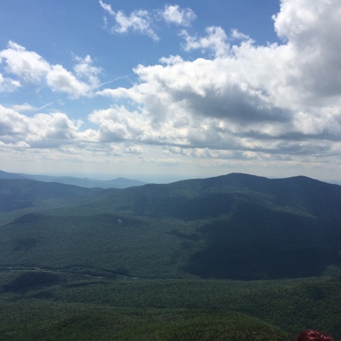
Reaching the top of Mt. Flume was exhilarating and we took a short time to take in the views. But we were behind schedule, and didn't eat a proper lunch. I was crestfallen despite the high of the ascent. I could see we would lose almost 1000 feet before we had to climb back up 1000 feet to gain the summit of Mt. Liberty in the distance, peak number two.

I had severely underestimated the elevation gain and loss we'd experience between these five peaks. This was no hike at all, and suddenly my pack felt a lot heavier as my morale weakened. It was a costly mistake, as it became painfully clear that our pace had slowed to an average of less than one mile per hour. The 10.3 miles to our chosen campsite, and only source of potable water, now seemed daunting and maybe impossible.
Did I mention water? We carried in four liters of water as well as a 16 oz. Gatorade each. Once you begin to ascend Flume, there are no water sources along the Franconia Ridge Trail. The next questionable water source is Garfield Pond at the base of Mt. Garfield. We'd hold out for the fresh water spring at the Garfield Ridge Campsite, our destination. Even with my Platypus Gravityworks filter, we didn't trust the dark, still water of Garfield Pond, and we couldn't evaluate the quality of the water or safely navigate a route to the shore when we'd finally arrive there at deepest twilight.


But I'm getting ahead of myself. After Flume came Liberty. We set a goal to summit by 1PM, and failed again, this time by over an hour. The reality of our pace was setting in, as the sun began to dip toward the western horizon, and three summits stood between us and camp.


The view of Mt. Lincoln ahead was stunning, and not just for its impressive beauty. I realized that at the highest, windiest points along this trail, we'd be climbing over the summit, pulling ourselves up over the rocks and boulders, not hiking. It took my breath away in more way than one, as I slouched under the weight of my pack. Another mistake: I wasn't eating, so there was no fuel for my legs, which were already screaming at me, and had been since our first climb of the day. Our pace deadened, and I required a five minute break after every 50 feet or so.


We link up with the Appalachian Trail, and the famed Franconia Ridge when we reach the top of Little Haystack Mountain. This peak is less than 5000 feet and sits between Liberty and Lincoln. After Mike actually had to physically help me carry my pack over several obstacles, we finally ascended Lincoln, completely alone as the orange and pink sun began its final descent, and we saw mighty Lafayette taunting us in the distance. We let out a hoot as we tapped the summit, and moved on, crossing over two strange rock formations that separate the two peaks.
By now it was 5:30PM and after taking nearly an hour to descend from Lincoln, we were climbing Mt. Lafayette, our fourth peak. The last of the day hikers were trickling down from the summit of Lincoln behind us, and the environment ahead quickly became surreal, inhospitable, lonely and alien. The wind was strong and offensive, almost lifting us up off the ground despite our leaden packs. A vulture circled ominously overhead above Lafayette's summit, which was rocky and twinned with tortured brush and pine clinging to the rocks and life, adorned with the foundation of an old Lodge that sat up here in the 60's. The only company we had were these strange cairns set along the trail to lead AT thru-hikers, or anyone unlucky enough to get stuck up here in bad weather through fog and clouds. They reminded me of the Pukel Men from the Paths of the Dead in the Lord of the Rings: the Return of the King. The cold winds prompts me to put on my down jacket and I quickly sweat out any and all water I'd actually consumed.

We finally reached the Garfield Ridge Trail junction on the north-side of Lafayette's summit, which would lead us to our final peak, Mt. Garfield, and our camp on the other side. It was 6:30PM, and we again foolishly convinced ourselves we'd move faster than we were capable, estimating that we'd reach camp before we lost daylight. Wrong again.
Now we could see how far away Garfield really was, and the full gravity of my mistake sank in. Exhausted, thirsty, and struggling to keep a good pace, what little morale I was maintaining was carried away in the wind, and lamented my miscalculation. But with no place to camp and no water source, there was no choice but to move forward. I took no more pictures that day. The entire focus became our safety and well being. We burned by Garfield Pond, not even pausing to consider the black water. Besides, the sun was long gone, and we couldn't see any manageable direct route to the water's edge. We had 32 oz. remaining to get us to camp.
Night descended upon the forest, and with it, our experience changed dramatically. The air became suddenly moist and the temperature plummeted, as a cacophony of crickets and nocturnal creatures awakened to sing their siren song. We were on the western side of Mt Garfield ascending when we lost twilight. I donned my headlamp and Mike attached his LED lamp to his shirt. It would be each of our first night hikes in the wilderness, an experience neither of us will ever forget. We weren't scared or panicky. A better way to describe it would be a hyper-vigilance. And it's a good thing, because at this point my legs had a bad case of the 'wobbles' and we were constantly slipping and sliding down slick and slimy rock formations in deep darkness.
Right as I began to question the route we took in the dark, we heard the sweet sound of the Garfield Ridge Campsite spring, and rounded a corner to the camp area's entry. We filtered, chugged down two liters each, then filled up again and hiked the final distance to the only open tent area at 10:30PM. The camp was full of residents, but everyone had already gone to bed for the night.
I made a feeble effort to prepare dinner in the cold and dark without disturbing our neighbors who were already sleeping when we set up. Mike took some hot chocolate and turned in for the night, and after a few bites of food, I stored our stuff in the bear box and settled into my tent. This didn't turn out to be the camping trip either of us had imagined, and the whiskey, pipe tobacco, and other treats go untouched.
In the morning I'm awake at 6AM and boy am I ready to go home. Mike takes some convincing to awaken, but soon were both packing up and drinking some hot coffee. We chat with our neighbors; they'd come up a 3 mile trail the previous day. Sounded a lot nicer than our slog across five peaks.
We're on the trail at 9AM, and it starts to get dangerous again fast. The trail drops down a cliff along drainage for a water way. They shouldn't even call it a trail. Mike and I slip and slide our way down from one hand hold to the next until we finally reach our junction with the Franconia Brook Trail. We take it, and the trail takes us down deep into the Pemigewasset Valley.

The going is muddy and wet, and sometimes some navigation is required, but overall today is a lot easier. I'll take stumps and sludge and minor navigation over the death march I led us on yesterday. We glide by a pair of beaver ponds, and cross a few treacherous brooks and streams by hopping across the rocks. It's a beautiful June day, the sun shining brightly sparkles and dances on the rushing water. It's been a brutal 36 hours, but its moments like this that make it worthwhile.

We hit our final junction, the Lincoln Woods Trail, the same one we started on, closing the loop. Soon we start to see more and more day hikers and know we're close to the end. By now I'm dizzy with dehydration, and nearly puked when I tried to choke down a nutrition bar. I did a horrible job managing my food and water intake on this trip. It's a miracle I even made it, but I'm happy this happened here on a weekend trip, not on the three week adventure I've got planned a month out.
Soon we see the sun shining on windshields of cars in the parking area. I'm grateful for the lessons I learned in the White Mountains, and Mike is grateful I didn't puke in his car 15 minutes after we merged onto the highway.
The JMT is only a month away.
No comments:
Post a Comment